Land north-west of Saunders Lane
The proposal in this area is for up to 147 new homes including 50 per cent affordable homes. This would include a mix of housing sizes and types including family housing, housing for first time buyers and houses suitable for 'downsizers'.
Land North West of Saunders Lane - Illustrative Masterplan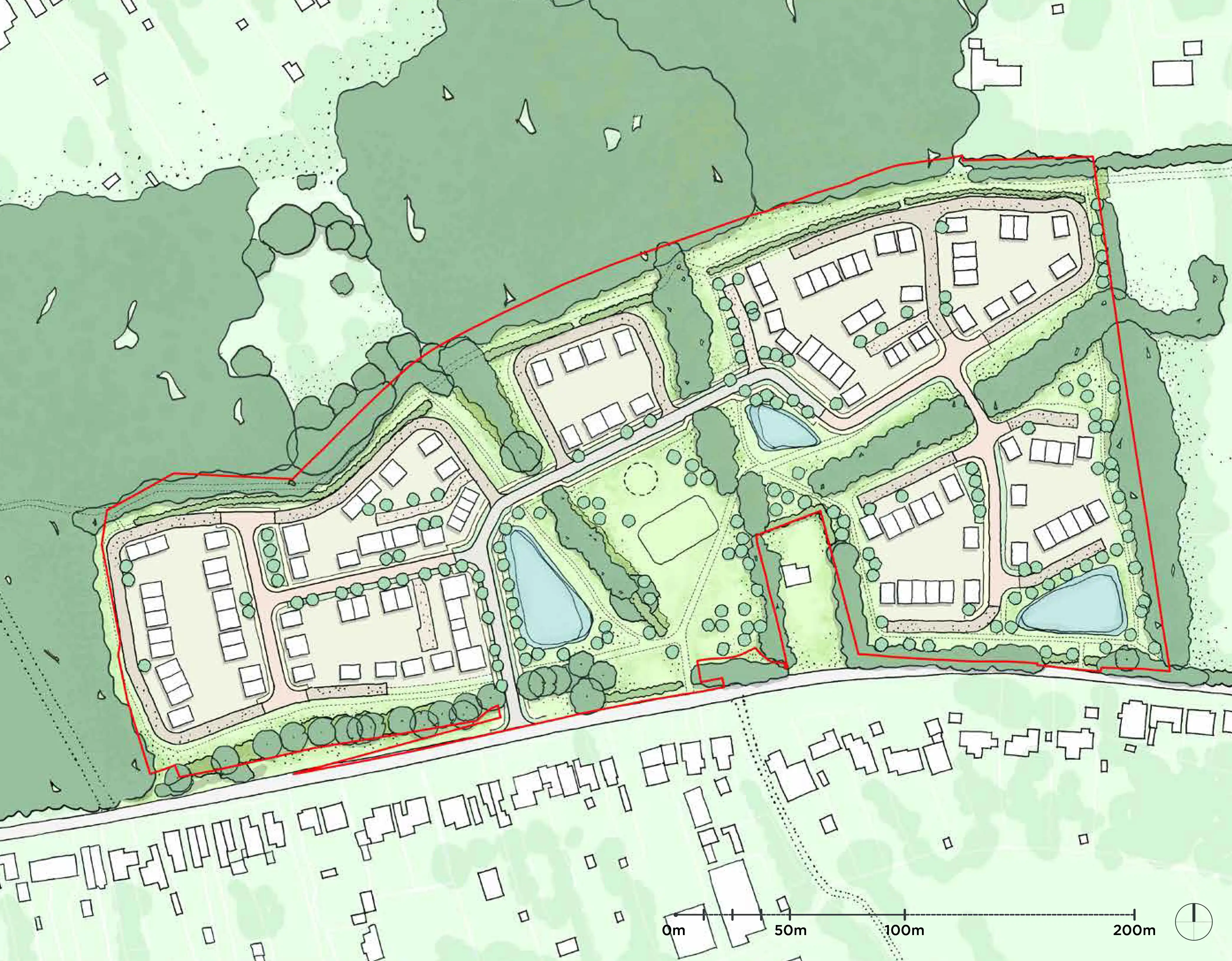
This approximately 7.61 hectares site lies to the north-west of Saunders Lane, Mayford. Our proposals here will provide:
Up to 147 high quality homes in a key location to ensure sensitive and sustainable much needed development 50% of homes as affordable housing A mix of housing sizes and types including family housing, housing for first time buyers and houses suitable for 'downsizers' Development in a sustainable location within walking and cycling distance of local facilities and services, primary and secondary schools Formalised walking routes, linking with wider public right of ways in the local area to encourage sustainable travel opportunities Over a third of the site given over to the provision of new public open space including informal recreation areas and formal play facilities Commitment to enriching and boosting nature and wildlife on the sites, securing 10% biodiversity net gain locally Commitment to carbon reduction and reducing energy demand of houses to allow future residents to benefit from lower energy costs Creation of jobs and investment during the construction phase, together with generation of investment in the local area Planning contributions, (S106 and Community Infrastructure Levy), to be agreed with Woking Borough Council, to support local infrastructure needs Additional public sector revenues through further council tax revenue.Access is proposed via a priority junction off Saunders Lane which routes east-west along the southern boundary of the site and is within a short walk of Mayford Village Hall as well as other local services including a convenience store, public house, businesses and schools.
We will seek to retain existing tree and hedgerow planting within the site and around its boundaries and will include additional tree and hedgerow planting through the site.
More detail on our plans for land north west of Saunders Lane can be found in our planning statement and Design and Access Statement. You can have your say and view the application (PLAN/2025/0832) here.
Land north-east of Saunders Lane
The proposal for this area is for up to 162 new homes including 50 per cent affordable homes. This would include a mix of housing sizes and types including family housing, housing for first time buyers and houses suitable for 'downsizers'.
Land North East of Saunders Lane - Illustrative Masterplan
This site, which is around 450m to the east of our other site, is approximately 6.56 hectares.
Our proposals for land north-east of Saunders Lane will provide:
Up to 162 high quality homes in a key location to ensure sensitive and sustainable much needed development that will contribute to meeting Woking's requirement to plan for new homes 50% of homes as affordable housing A mix of housing sizes and types including family housing, housing for first time buyers and houses suitable for 'downsizers' Formalised walking routes, linking with wider public right of ways in the local area to encourage sustainable travel opportunities Over a third of the site given over to the provision of new public open space including informal recreation areas and formal play facilities Commitment to enriching and boosting nature and wildlife on the sites, securing 10% biodiversity net gain locally Commitment to carbon reduction and reducing energy demand of houses to allow future residents to benefit from lower energy costs Creation of jobs and investment during the construction phase, together with generation of investment in the local area Planning contributions, (S106 and Community Infrastructure Levy), to be agreed with Woking Borough Council, to support local infrastructure needs Additional public sector revenues through further council tax revenue.Access to the site is proposed via a single priority junction from Saunders Lane. We are also proposing a new pedestrian access from Saunders Lane which would connect to the existing footway on the north side of Saunders Lane and provide a dedicated pedestrian route into the site.
The design also includes a bollard controlled emergency, pedestrian and cycle access onto Hook Hill Lane. This will ensure emergency access is maintained at all times.
We will seek to retain and enhance tree and hedgerow planting around the edge of the site.
More detail on our plans for land north east of Saunders Lane can be found in our planning statement and Design and Access Statement. You can have your say and view the application (PLAN/2025/0831) here.
Aerial Visualisation of both sites
The planning context
Both the sites were previously identified as proposed sites in Woking Borough Council’s draft Site Allocations Development Plan Document (DPD) (June 2015).
National planning policy has changed since then, and the Woking Local Development Plan policies are now out-of-date. As a result, Woking Borough Council has started work on a new Local Plan.
While the parcels of land are in the Green Belt, they are considered to meet the criteria in the new National Planning Policy Framework (NPPF) (2024) for Grey Belt status. There is a demonstrable unmet need for the type of housing we are proposing, and the sites are in a sustainable location. This means that the development of the two sites for homes would not be inappropriate.
The council’s Green Belt Assessment (2014) also recommended removal of the land from the Green Belt to accommodate future development based on the sites’ low contribution to the Green Belt purposes.
As a result of the new Government’s housing targets, Woking Borough Council’s housing needs have increased from 292 in the adopted Core Strategy (2012) to 794 new homes a year now based on the new NPPF (2024).
Very little new affordable housing has been delivered across the borough.
Our plans will help towards Woking Borough Council meeting its increasing housing needs